


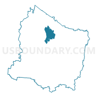
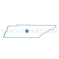
03-1 Leana Community Center Voting District, Rutherford County, Tennessee
About
Outline

Summary
| Unique Area Identifier | 669469 |
| Name | 03-1 Leana Community Center Voting District |
| County | Rutherford County |
| State | Tennessee |
| Area (square miles) | 13.71 |
| Land Area (square miles) | 13.71 |
| Water Area (square miles) | 0.01 |
| % of Land Area | 99.96 |
| % of Water Area | 0.04 |
| Latitude of the Internal Point | 35.94856850 |
| Longtitude of the Internal Point | -86.41651340 |
Maps

Graphs
Select a template below for downloading or customizing gragh for 03-1 Leana Community Center Voting District, Rutherford County, Tennessee


Neighbors
Neighoring Voting District (by Name) Neighboring Voting District on the Map
- 02-2 Walter Hill School Voting District, Rutherford County, TN
- 03-2 Nissan Activity Center Voting District, Rutherford County, TN
- 03-3 Wilson Elementary School Voting District, Rutherford County, TN
- 14-2 Siegal Elementary School Voting District, Rutherford County, TN
- 19-2 Seigel Middle School Voting District, Rutherford County, TN
- 20-2 Blackman Middle School Voting District, Rutherford County, TN
Top 10 Neighboring County Subdivision (by Population) Neighboring County Subdivision on the Map
- District 20, Rutherford County, TN (16,296)
- District 2, Rutherford County, TN (12,397)
- District 3, Rutherford County, TN (12,027)
- District 14, Rutherford County, TN (9,468)
- District 19, Rutherford County, TN (8,837)
Top 10 Neighboring Place (by Population) Neighboring Place on the Map
Top 10 Neighboring Elementary School District (by Population) Neighboring Elementary School District on the Map
Top 10 Neighboring Secondary School District (by Population) Neighboring Secondary School District on the Map
Top 10 Neighboring Unified School District (by Population) Neighboring Unified School District on the Map
Top 10 Neighboring State Legislative District Lower Chamber (by Population) Neighboring State Legislative District Lower Chamber on the Map
Top 10 Neighboring State Legislative District Upper Chamber (by Population) Neighboring State Legislative District Upper Chamber on the Map
Top 10 Neighboring 111th Congressional District (by Population) Neighboring 111th Congressional District on the Map
Top 10 Neighboring Census Tract (by Population) Neighboring Census Tract on the Map
- Census Tract 411.01, Rutherford County, TN (7,490)
- Census Tract 405.01, Rutherford County, TN (6,989)
- Census Tract 405.02, Rutherford County, TN (6,609)
- Census Tract 410, Rutherford County, TN (6,500)
- Census Tract 413.01, Rutherford County, TN (5,128)
- Census Tract 409.01, Rutherford County, TN (2,722)